
If you are like me, you probably grew up in Cary, FRG, or some unremarkable location near them. If this is the case, chances are that you have noticed how a ton of things changed as you grew up. Whether it be people, places, the seasons, or something else, it is clear that things never stay the same.
Of course, there are some people who may reflect on the past and talk about how good it was back then. Fortunately for people feeling that nostalgia, there is a way for them to go back in time, but from above.
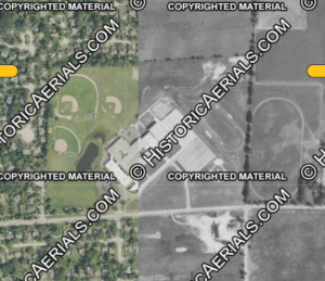
The website Historic Aerials allows you to see what any place in the USA looked like years, decades, and almost a century ago using satellite images taken for the area.
Aside from looking at the images, you can compare and contrast old and new images using the “compare tool,” view even older topographic maps using the “topos” tool, and much more.
Using CGHS as an example, you can see how it looked like over 60 years ago, when it was brand new. You can see that almost all of the area around the school is pretty much barren, which I found shocking.
There are many other interesting things that I found while exploring, like how Chicago looks almost unrecognizable in 1889. Historic Aerials is not only a cool tool to see how the USA was like back then, but also a way to discover something cool about your hometown that may no longer be there.